Columbia Basin Institute of Regional History (CBIRH): 0460
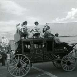
Fort Steele Stage On Parade
This replica stagecoach was sup0plied to Fort Steele by Victoria. It served as transportation around Fort Steele for several years until Fort Steele built a "people wagon," at which point this fibreglass stagecoach was sent to Barkerville. The parqade is believed to be at Cranbrook.
| Internal ID: | 0460.0001 |
|---|---|
| Medium: | Photograph |
| Date: | 1970 |
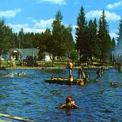
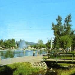
Cranbrook's Gyro Swimming Pool
The Gyro Pool located in Baker Park, Cranbrook, B.C. The Gyro fountain is visible, as is the entrance building to the Tourist Park. Gyro Pool was advertised as the largest outdoor pool in western Canada.
| Internal ID: | 0460.0002 |
|---|---|
| Medium: | Photograph |
| Date: | 1970 |
Cranbrook's Gyro Swimming Pool
The Gyro Pool located in Baker Park, Cranbrook, B.C. The Gyro fountain is visible, as is the entrance building to the Tourist Park. Gyro Pool was advertised as the largest outdoor pool in western Canada.
| Internal ID: | 0460.0003 |
|---|---|
| Medium: | Photograph |
| Date: | 1970 |
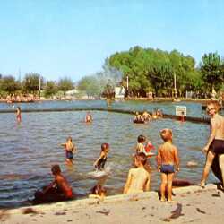
Cranbrook's Gyro Swimming Pool
The Gyro Pool located in Baker Park, Cranbrook, B.C. The Gyro fountain is visible as is the divider laying out the shallow pool. Note the sand beach installed along two sides.
| Internal ID: | 0460.0004 |
|---|---|
| Medium: | Photograph |
| Date: | 0000 |
Cranbrook's Gyro Swimming Pool
The Gyro Pool located in Baker Park, Cranbrook, B.C. The Gyro fountain is visible as is the divider laying out the shallow pool. Note the sand beach installed along two sides.
| Internal ID: | 0460.0005 |
|---|---|
| Medium: | Photograph |
| Date: | 0000 |
Cranbrook's Gyro Swimming Pool
The Gyro Pool located in Baker Park, Cranbrook, B.C. The Gyro fountain is visible as are two low diving boards. This view is from the east, showing bridges connecting the pool to Baker Park.
| Internal ID: | 0460.0006 |
|---|---|
| Medium: | Photograph |
| Date: | 1965 |
Cranbrook's Gyro Swimming Pool
The Gyro Pool located in Baker Park, Cranbrook, B.C. The Gyro fountain is visible as are two low diving boards. This view is from the east, showing bridges connecting the pool to Baker Park.
| Internal ID: | 0460.0007 |
|---|---|
| Medium: | Photograph |
| Date: | 1965 |
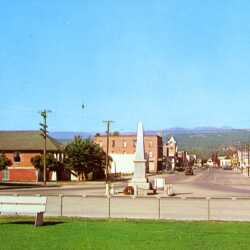
Cranbrook Cenotaph on Baker Street
A view of Baker Street from the east. The foreground lawn is in front of the Government Building. To the right is the United Church followed by the Royal Canadian Legion building. On the right is the Super Valu store.
| Internal ID: | 0460.0008 |
|---|---|
| Medium: | Photograph |
| Date: | 1965 |
Cranbrook Cenotaph on Baker Street
A view of Baker Street from the east. The foreground lawn is in front of the Government Building. To the right is the United Church followed by the Royal Canadian Legion building. On the right is the Super Valu store.
| Internal ID: | 0460.0009 |
|---|---|
| Medium: | Photograph |
| Date: | 1965 |
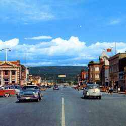
Baker Street, Cranbrook, from the West
Looking down Baker Street with a good view on the right of the Cranbrook Trading Co. building, the tower of the old Post Office and the brick Hanson Block midway on the right. The imposing building with pillars on the left is the Canadian Bank of Commerce.
| Internal ID: | 0460.0010 |
|---|---|
| Medium: | Photograph |
| Date: | 1960 |
Baker Street, Cranbrook, from the West
Looking down Baker Street with a good view on the right of the Cranbrook Trading Co. building, the tower of the old Post Office and the brick Hanson Block midway on the right. The imposing building with pillars on the left is the Canadian Bank of Commerce.
| Internal ID: | 0460.0011 |
|---|---|
| Medium: | Photograph |
| Date: | 1960 |
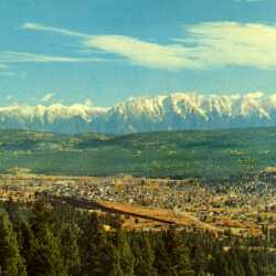
Overview of Cranbrook and the Steeples Range
An overview of Cranbrook taken from the west showing the CPR rail yards with the city sprawling behind. In the distance is the imposing Steeples Range of the Canadian Rockies.
| Internal ID: | 0460.0012 |
|---|---|
| Medium: | Photograph |
| Date: | 1965 |
Overview of Cranbrook and the Steeples Range
An overview of Cranbrook taken from the west showing the CPR rail yards with the city sprawling behind. In the distance is the imposing Steeples Range of the Canadian Rockies.
| Internal ID: | 0460.0013 |
|---|---|
| Medium: | Photograph |
| Date: | 1965 |
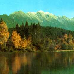
The Steeples Range
A small lake in the foreground (possibly Garbutts Lake) is showcased by the Steeples Range with its first dusting of fall snow.
| Internal ID: | 0460.0014 |
|---|---|
| Medium: | Photograph |
| Date: | 1965 |
The Steeples Range
A small lake in the foreground (possibly Garbutts Lake) is showcased by the Steeples Range with its first dusting of fall snow.
| Internal ID: | 0460.0015 |
|---|---|
| Medium: | Photograph |
| Date: | 1965 |
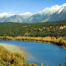
Kootenay River and The Steeples
An autumn view of the Kootenay River framed by the snow-capped Steeples Range, before the construction of the Libby Dam.
| Internal ID: | 0460.0016 |
|---|---|
| Medium: | Photograph |
| Date: | 1965 |
Kootenay River and The Steeples
An autumn view of the Kootenay River framed by the snow-capped Steeples Range, before the construction of the Libby Dam.
| Internal ID: | 0460.0017 |
|---|---|
| Medium: | Photograph |
| Date: | 1965 |
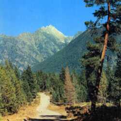
Mount Fisher
Mount Fisher, the highest mountain in the southern Rockies, looking from the Wild Horse Creek forestry road.
| Internal ID: | 0460.0018 |
|---|---|
| Medium: | Photograph |
| Date: | 1965 |
Mount Fisher
Mount Fisher, the highest mountain in the southern Rockies, looking from the Wild Horse Creek forestry road.
| Internal ID: | 0460.0019 |
|---|---|
| Medium: | Photograph |
| Date: | 1965 |
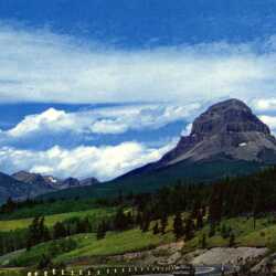
Crowsnest Mountain from Highway 3
Crowsnest Mountain from Highway ,. c. 1965. Crowsnest Mountain dominates the Alberta landscape, marking the eastern entrance to the Crowsnest Pass.
| Internal ID: | 0460.0022 |
|---|---|
| Medium: | Photograph |
| Date: | 1965 |
Crowsnest Mountain from Highway 3
Crowsnest Mountain from Highway ,. c. 1965. Crowsnest Mountain dominates the Alberta landscape, marking the eastern entrance to the Crowsnest Pass.
| Internal ID: | 0460.0023 |
|---|---|
| Medium: | Photograph |
| Date: | 1965 |
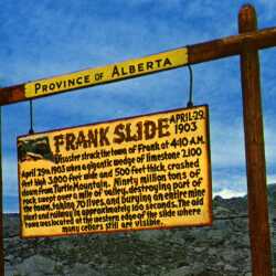
Frank Slide Interpretive Sign
The Frank Slide, c. 1965. A Province of Alberta interpretation panel marks the April 29, 1903 occurrence of the Frank Slide. Turtle Mountain lost a huge slab of limestone in the dark of night, resulting in the obliteration of part of the community of Frank, AB.
| Internal ID: | 0460.0024 |
|---|---|
| Medium: | Photograph |
| Date: | 1965 |
Frank Slide Interpretive Sign
The Frank Slide, c. 1965. A Province of Alberta interpretation panel marks the April 29, 1903 occurrence of the Frank Slide. Turtle Mountain lost a huge slab of limestone in the dark of night, resulting in the obliteration of part of the community of Frank, AB.
| Internal ID: | 0460.0025 |
|---|---|
| Medium: | Photograph |
| Date: | 1965 |
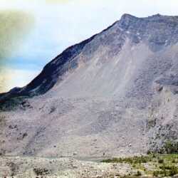
The Frank Slide, c. 1965
The Frank Slide, c. 1965. A view of Turtle Mountain showing the huge loss of limestone resulting from the 1903 Frank Slide.
| Internal ID: | 0460.0026 |
|---|---|
| Medium: | Photograph |
| Date: | 1965 |
The Frank Slide, c. 1965
The Frank Slide, c. 1965. A view of Turtle Mountain showing the huge loss of limestone resulting from the 1903 Frank Slide.
| Internal ID: | 0460.0027 |
|---|---|
| Medium: | Photograph |
| Date: | 1965 |
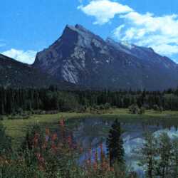
Mount Rundle and Banff National Park
Mount Rundle in Banff National Park. A promotional view of Banff National Park showing Mount Rundle towering in the background.
| Internal ID: | 0460.0028 |
|---|---|
| Medium: | Photograph |
| Date: | 1965 |
Mount Rundle and Banff National Park
Mount Rundle in Banff National Park. A promotional view of Banff National Park showing Mount Rundle towering in the background.
| Internal ID: | 0460.0029 |
|---|---|
| Medium: | Photograph |
| Date: | 1965 |
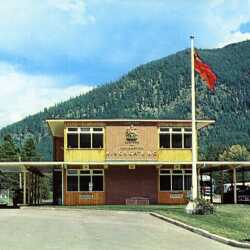
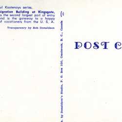
Kingsgate Border Crossing. c 1965.
A view of the Kingsgate border crossing from the US side. It is listed on this postcard as 'the second largest port of entry into British Columbia.'
| Internal ID: | 0460.0030 |
|---|---|
| Medium: | Photograph |
| Date: | 1965 |
Kingsgate Border Crossing. c 1965.
A view of the Kingsgate border crossing from the US side. It is listed on this postcard as 'the second largest port of entry into British Columbia.'
| Internal ID: | 0460.0031 |
|---|---|
| Medium: | Photograph |
| Date: | 1965 |