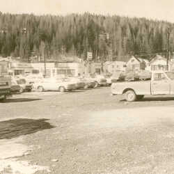
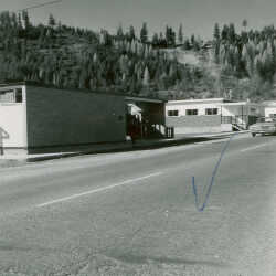
Parking Lot
Parking lot, where the Rhine Castle Inn was built, Wallinger Avenue and Ross Street, Kimberley, BC At present date 1989, now Inn of the Rockies.
| Internal ID: |
0205.0250 |
| Medium: | Photograph |
|---|
| Date: |
1970 |
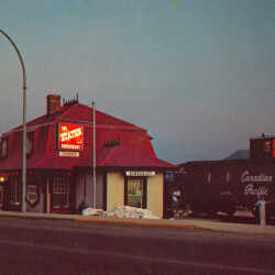
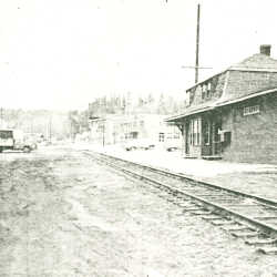
The Station Restaurant
Kimberley BC, The Bavarian City of the Canadian Rockies. The Station on Ross Street, built in 1901 used until 1968 for CPR then converted to a restaurant.
| Internal ID: |
0205.0300 |
| Medium: | Postcard |
|---|
| Date: |
1970 |
The Station Restaurant
Kimberley BC, The Bavarian City of the Canadian Rockies. The Station on Ross Street, built in 1901 used until 1968 for CPR then converted to a restaurant.
| Internal ID: |
0205.0301 |
| Medium: | Postcard |
|---|
| Date: |
1970 |
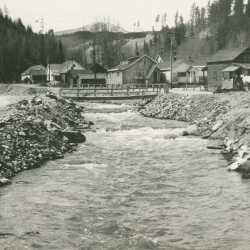
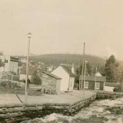
Mark Creek
Foot bridge across Mark Creek, from Ross Street to Deer Park Avenue, Kimberley, BC.
| Internal ID: |
0205.0338 |
| Medium: | Photograph |
|---|
| Date: |
1930 |
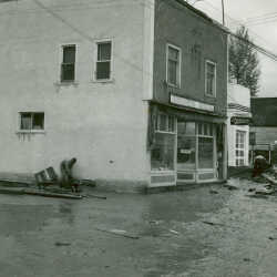
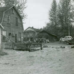
Fabco Store
Fabco store corner of Wallinger Avenue and Ross Street, Kimberley, BC
| Internal ID: |
0205.0340 |
| Medium: | Photograph |
|---|
| Date: |
1925 |
Mark Creek
Mark Creek in foreground, Ross Street on left of creek, Kimberley, BC.
| Internal ID: |
0205.0342 |
| Medium: | Photograph |
|---|
| Date: |
1929 |
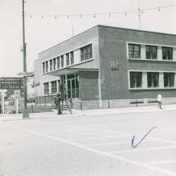
Post Office
Kimberley Post Office, corner of Wallinger Avenue and Ross Street, downtown Kimberley, BC.
| Internal ID: |
0205.0376 |
| Medium: | Photograph |
|---|
| Date: |
1960 |
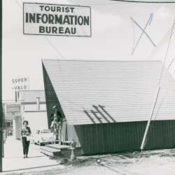
Tourist Information Bureau
Tourist Information Bureau, Ross Street, Kimberley, BC.
| Internal ID: |
0205.0379 |
| Medium: | Photograph |
|---|
| Date: |
1960 |
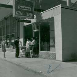
Launderette
King Koin Launderette, Ross Street, Kimberley, BC.
| Internal ID: |
0205.0380 |
| Medium: | Photograph |
|---|
| Date: |
1960 |
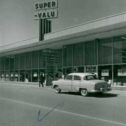
Super Valu
Super Valu on Ross Street, Kimberley, BC
| Internal ID: |
0205.0381 |
| Medium: | Photograph |
|---|
| Date: |
1955 |
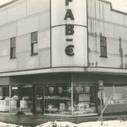
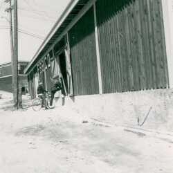
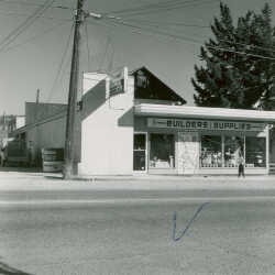
Fabco Building Supply
Fabco Building Supply, Ross Street, Kimberley, BC
| Internal ID: |
0205.0382 |
| Medium: | Photograph |
|---|
| Date: |
1960 |
Kimberley Railway Station
Kimberley Station after closure and prior to renovation as a restaurant. Taken by the Daily Bulletin, Kimberley, BC, Friday April 26, 1974.
| Internal ID: |
0218.0003 |
| Medium: | Ephemera |
|---|
| Date: |
April 26th 1974 |
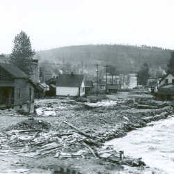
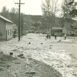
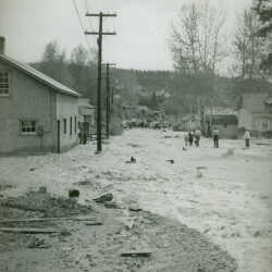
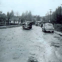
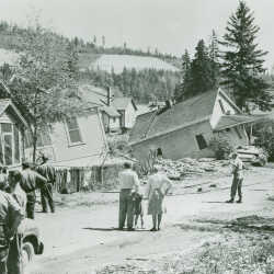
Mark Creek Flood 1948
Mark Creek Flood: View of Ross Street, looking east; June 1, 1948
| Internal ID: |
0303.0008 |
| Medium: | Photograph |
|---|
| Date: |
May 1st 1948 |
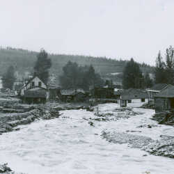
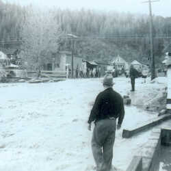
Mark Creek Flood 1948
Mark Creek Flood - Flooding in residential area, Ross Street, looking east; June 1, 1948
| Internal ID: |
0303.0011 |
| Medium: | Photograph |
|---|
| Date: |
June 1st 1948 |
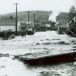
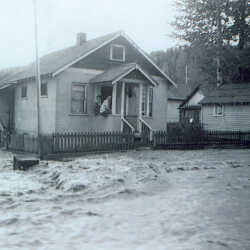
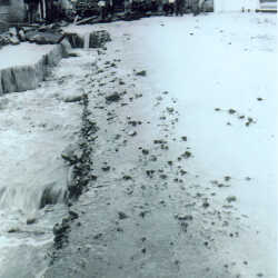
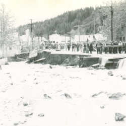
Mark Creek Flood 1948
Mark Creek Flood: Ross Street under water; May 24, 1948
| Internal ID: |
0303.0046 |
| Medium: | Photograph |
|---|
| Date: |
May 24th 1948 |
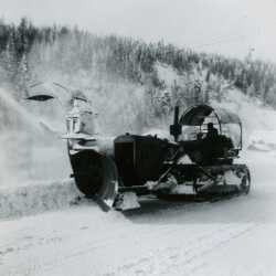
Snow Blower January 1954, Kimberley, BC
Snow Blower on Ross St in Kimberley, BC January 1954
| Internal ID: |
2298.0057 |
| Medium: | Photograph |
|---|
| Date: |
1954 |
Mark Creek Flood 1948 Kimberley, B.C
Mark Creek Flood 1948 Kimberley, B.C. Showing Muracaâ??s Grocery on the corner of Wallinger Avenue and Mark Street
| Internal ID: |
0199.0064 |
| Medium: | Photograph |
|---|
| Date: |
1948 |
Mark Creek Flood 1948 Kimberley, B.C
Mark Creek flood 1948 Kimberley, B.C Showing Mark Street leading into Rotary Drive
| Internal ID: |
0199.0065 |
| Medium: | Photograph |
|---|
| Date: |
1948 |
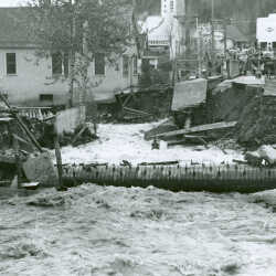
Mark Creek Flood 1948 Kimberley, B.C.
Mark Creek Flood 1948 Kimberley, B.C Showing Mark Street flooded, photo by Goodman
| Internal ID: |
0199.0111 |
| Medium: | Photograph |
|---|
| Date: |
1948 |
Mark Creek Flood 1948 Kimberley, B.C.
Mark Creek Flood 1948 Kimberley, B.C Showing the damage to the corner of Mark Street and Wallinger Avenue during the flood.
| Internal ID: |
0199.0121 |
| Medium: | Photograph |
|---|
| Date: |
1948 |
Mark Creek Flood 1948 Kimberley, B.C.
Mark Creek Flood 1948 Kimberley, B.C Showing the corner of Jennings Avenue and Mark Street, photo by Les Rimes
| Internal ID: |
0199.0150 |
| Medium: | Photograph |
|---|
| Date: |
1948 |
Mark Creek Flood 1948 Kimberley, B.C.
Mark Creek Flood 1948 Kimberley, B.C Showing Mark Street during the flood.
| Internal ID: |
0199.0153 |
| Medium: | Photograph |
|---|
| Date: |
1948 |
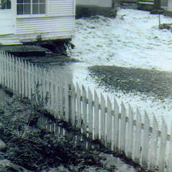
Mark Creek Flood 1948 Kimberley, B.C.
Mark Creek Flood 1948 Kimberley, B.C. Showing a house surrounded by the flood water on Mark Street, below Wallinger Avenue bridge.
| Internal ID: |
0199.0160 |
| Medium: | Photograph |
|---|
| Date: |
0000 |
Mark Creek Flood 1948 Kimberley, B.C.
Mark Creek Flood 1948 Kimberley, B.C Showing Mark Street looking towards Wallinger Avenue bridge.
| Internal ID: |
0199.0162 |
| Medium: | Photograph |
|---|
| Date: |
1948 |
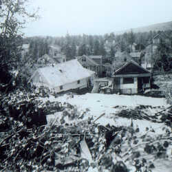
Aftermath of Mark Creek Flood 1948 Kimberley, B.C.
Aftermath of Mark Creek Flood 1948 Kimberley, B.C. Showing Cars on flooded Mark Street well the flood water was receding.
| Internal ID: |
0199.0167 |
| Medium: | Photograph |
|---|
| Date: |
1948 |
Mark Creek Flood 1948 Kimberley, B.C.
Mark Creek Flood 1948 Kimberley, B.C Showing houses that the flood water has been eating away at on the backside of Mark Street, near Wallinger Avenue bridge.
| Internal ID: |
0199.0168 |
| Medium: | Photograph |
|---|
| Date: |
1948 |
Mark Creek Flood 1948 Kimberley, B.C.
Mark Creek Flood 1948 Kimberley, B.C Showing Mark Street, near Wallinger Avenue bridge
| Internal ID: |
0199.0174 |
| Medium: | Photograph |
|---|
| Date: |
1948 |
Aftermath of Mark Creek Flood 1948 Kimberley, B.C.
Aftermath of Mark Creek Flood 1948 Kimberley, B.C. Showing Wallinger Avenue and Mark Street intersection.
| Internal ID: |
0199.0221 |
| Medium: | Photograph |
|---|
| Date: |
1948 |
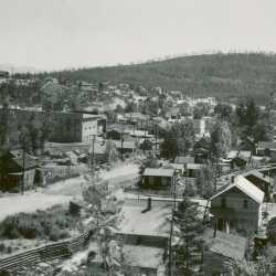
View of Kimberley, BC
View of Kimberley, BC showing Mark Street.
| Internal ID: |
0205.0136 |
| Medium: | Photograph |
|---|
| Date: |
1929 |
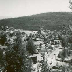
View of Kimberley, BC
View of Kimberley, B.C., looking east on Mark Street.
| Internal ID: |
0205.0140 |
| Medium: | Photograph |
|---|
| Date: |
1929 |
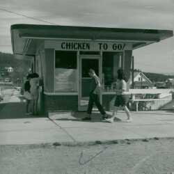
Chicken to Go
Chicken To Go restaurant, corner of Wallinger Avenue and Mark Street, downtown Kimberley, BC.
| Internal ID: |
0205.0374 |
| Medium: | Photograph |
|---|
| Date: |
1960 |
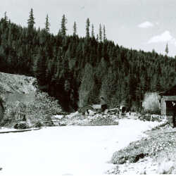
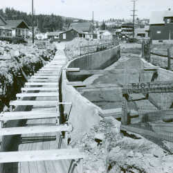
Mark Creek Reconstruction 1956
Mark Creek Reconstruction: Deer Park Avenue from Mark Street Bridge; Sept. 6, 1956
| Internal ID: |
0303.0086 |
| Medium: | Photograph |
|---|
| Date: |
September 6th 1956 |
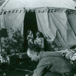
Aftermath of Mark Creek Flood 1948 Kimberley, B.C.
Aftermath of Mark Creek Flood 1948 Kimberley, B.C. Showing the tent camp for the flood victims that was located at the top of Catholic Church hill. Notice the Hydro Meter on the side of the tent.
Do you recognize this family? If you do please let us know
| Internal ID: |
0199.0194 |
| Medium: | Photograph |
|---|
| Date: |
1948 |
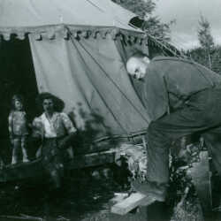
Aftermath of Mark Creek Flood 1948 Kimberley, B.C.
Aftermath of Mark Creek Flood 1948 Kimberley, B.C. Showing the tent camp for the flood victims that was located at the top of Catholic Church hill. Do you recognize this family? If you do please let us know
| Internal ID: |
0199.0195 |
| Medium: | Photograph |
|---|
| Date: |
1948 |
Pioneer Lodge
View of Pioneer Lodge and Blondie Wilson extensions, Church Avenue, Kimberley, BC
| Internal ID: |
0205.0252 |
| Medium: | Photograph |
|---|
| Date: |
1970 |
Viewpoint Apartment Construction
Viewpoint Apartment construction on Norton Avenue, Kimberley, BC
| Internal ID: |
0205.0387 |
| Medium: | Photograph |
|---|
| Date: |
1966 |
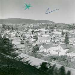
View of Kimberley
View from above Swan Avenue, looking toward city centre, Kimberley, BC
| Internal ID: |
0205.0386 |
| Medium: | Photograph |
|---|
| Date: |
1966 |
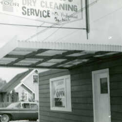
Dry Cleaners
Dry cleaners on Warren Avenue, Kimberley, BC.
| Internal ID: |
0205.0014 |
| Medium: | Photograph |
|---|
| Date: |
1960 |
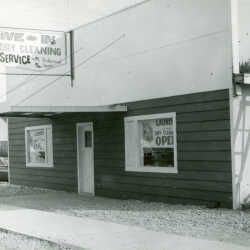
Dry Cleaners
Dry cleaners on Warren Avenue, Kimberley, BC.
| Internal ID: |
0205.0015 |
| Medium: | Photograph |
|---|
| Date: |
1960 |
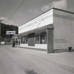
Tony's Store
Tony's located on Warren Ave, Kimberley, BC (Na Na's Pizza is there now).
| Internal ID: |
0205.0025 |
| Medium: | Photograph |
|---|
| Date: |
1960 |
Dog n Suds
Opening of Dog 'n' Suds on Warren Avenue, Kimberley, BC.
| Internal ID: |
0205.0026 |
| Medium: | Photograph |
|---|
| Date: |
1965 |
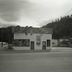
OK Tire
OK Tire on Warren Avenue, Kimberley, BC
| Internal ID: |
0205.0029 |
| Medium: | Photograph |
|---|
| Date: |
1965 |
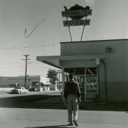
Overwaitea Foods
First Overwaitea Foods on Warren Avenue, Kimberley, BC
| Internal ID: |
0205.0043 |
| Medium: | Photograph |
|---|
| Date: |
1960 |
Blarchmont Hardware
Blarchmont Hardware on Warren Avenue, Kimberley, BC.
| Internal ID: |
0205.0044 |
| Medium: | Photograph |
|---|
| Date: |
1960 |
BC Tel Building
BC Tel Building at left, Jehovah's Witness Hall on right, on Warren Avenue, Kimberley, BC
| Internal ID: |
0205.0045 |
| Medium: | Photograph |
|---|
| Date: |
1960 |
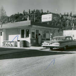
Super Stop Drive-In
Super Stop Drive-in Restaurant, Warren Avenue, Kimberley, BC.
| Internal ID: |
0205.0046 |
| Medium: | Photograph |
|---|
| Date: |
1960 |
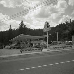
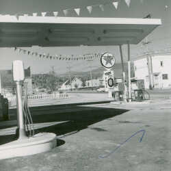
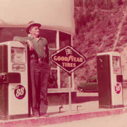
Texaco Station
Texaco Station, Warren Avenue, Kimberley, BC (note: Warren Banks Apartments in background).
| Internal ID: |
0205.0047 |
| Medium: | Photograph |
|---|
| Date: |
1960 |
Chevron Station
Chevron Station, Warren Avenue, Kimberley, BC Kimbrook Motor Hotel in background.
| Internal ID: |
0205.0048 |
| Medium: | Photograph |
|---|
| Date: |
1960 |
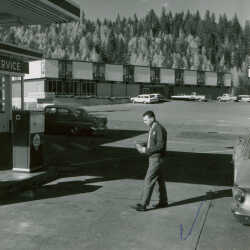
Peerless Motors
Peerless Motors, 1625 Warren Avenue, Kimberley, BC (note ski jump in background with platforms).
| Internal ID: |
0205.0053 |
| Medium: | Photograph |
|---|
| Date: |
1954 |
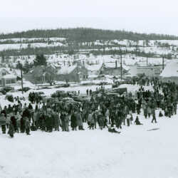
Kimberley Skiing
Bottom of ski jump with crowd in foreground, houses in the background on Warren Avenue, Kimberley, B.C., Feb. 24, 1957.
| Internal ID: |
0230.0213 |
| Medium: | Photograph |
|---|
| Date: |
February 24th 1957 |
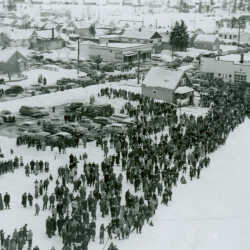
Kimberley Skiing
Lower Blarchmont hill showing bottom of ski jump taken from up the hill - shows crowd, houses, cars, etc., Kimberley, B.C.
| Internal ID: |
0230.0214 |
| Medium: | Photograph |
|---|
| Date: |
February 24th 1957 |
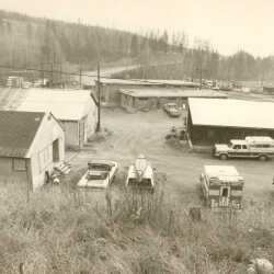
City Works Yard
City Works Yard, Knighton Road, Kimberley, BC
| Internal ID: |
0205.0254 |
| Medium: | Photograph |
|---|
| Date: |
1980 |
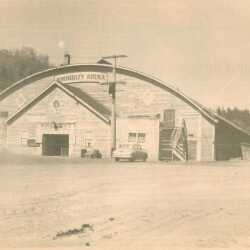
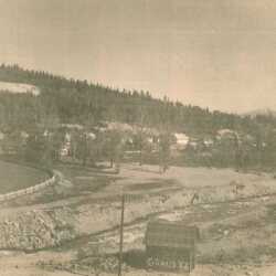
Do You Remember?
Newspaper clip - Do You Remember? These photos, taken back in the 1950's, show a section of town that has changed considerably. First picture is the old arena as it looked after it was condemned and shut down at the site of the current Centennial House on Wallinger Avenue. Second photo: the Rotary Park area looking down from Blarchmont Hill, before construction of the Civic Centre, Curling Rink and later the tennis courts, on Archibald Street and Rotary Drive, Kimberley, BC
| Internal ID: |
0205.0390 |
| Medium: | Ephemera |
|---|
| Date: |
1950 |
Do You Remember?
Newspaper clip - Do You Remember? These photos, taken back in the 1950's, show a section of town that has changed considerably. First picture is the old arena as it looked after it was condemned and shut down at the site of the current Centennial House on Wallinger Avenue. Second photo: the Rotary Park area looking down from Blarchmont Hill, before construction of the Civic Centre, Curling Rink and later the tennis courts, on Archibald Street and Rotary Drive, Kimberley, BC
| Internal ID: |
0205.0391 |
| Medium: | Ephemera |
|---|
| Date: |
1950 |
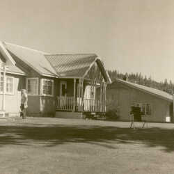
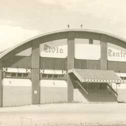
Civic Centre
Kimberley's new Civic Centre on Archibald Street and Rotary Drive, Kimberley, BC
| Internal ID: |
0205.0398 |
| Medium: | Photograph |
|---|
| Date: |
1964 |
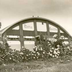
Civic Centre
Civic Centre, after Bavarianization, on Archibald Street and Rotary Drive, Kimberley, BC
| Internal ID: |
0205.0399 |
| Medium: | Photograph |
|---|
| Date: |
1975 |
Civic Centre
Civic Centre after Bavarianization, Archibald Street and Rotary Drive, Kimberley, BC
| Internal ID: |
0205.0400 |
| Medium: | Photograph |
|---|
| Date: |
1975 |
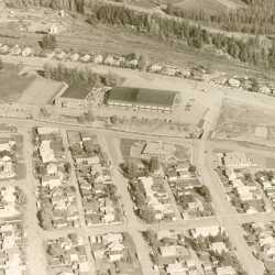
Aerial view of Civic Centre
Aerial view of Civic Centre, Archibald Street and Rotary Drive, Kimberley, BC
| Internal ID: |
0205.0401 |
| Medium: | Photograph |
|---|
| Date: |
1975 |
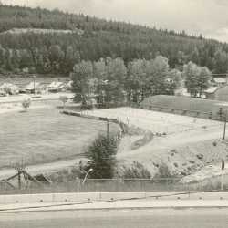
Civic Centre Grounds
Civic Centre, Tennis Courts and Ball Park, Archibald Street and Rotary Drive, Kimberley, BC.
| Internal ID: |
0205.0402 |
| Medium: | Photograph |
|---|
| Date: |
1975 |
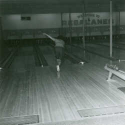
Kimberley Bowling
Regalanes Bowling Alley on Archibald Street, Kimberley, B.C., c. 1966.
| Internal ID: |
0230.0331 |
| Medium: | Photograph |
|---|
| Date: |
1966 |
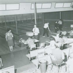
Kimberley Bowling
Interior of Regalanes Bowling Alley on Archibald Street, Kimberley, B.C., c. 1966.
| Internal ID: |
0230.0333 |
| Medium: | Photograph |
|---|
| Date: |
1966 |
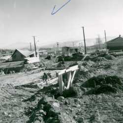
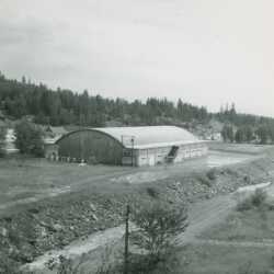
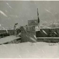
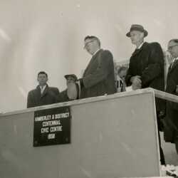
Construction of Kimberley's Centennial Civic Centre 1958
Construction of Kimberley's Centennial Civic Centre 1958. The arena is located on Rotary Drive and Archibald Street.
| Internal ID: |
2310.0009 |
| Medium: | Photograph |
|---|
| Date: |
December 29th 1958 |
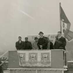
Kimberley Centennial Civic Centre 1958
Dedication of the Kimberley Centennial Civic Centre December 29th, 1958
| Internal ID: |
2310.0010 |
| Medium: | Photograph |
|---|
| Date: |
December 29th 1958 |
Kimberley Centennial Civic Centre 1958
Dedication of the Kimberley Centennial Civic Centre December 29th, 1958
| Internal ID: |
2310.0011 |
| Medium: | Photograph |
|---|
| Date: |
December 29th 1959 |
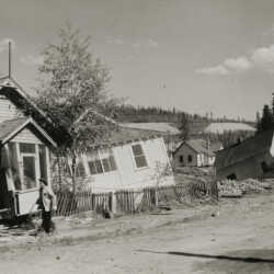
Aftermath of Mark Creek Flood 1948 Kimberley, B.C.
Aftermath of Mark Creek Flood 1948 Kimberley, B.C. Showing houses falling down bank of Mark Creek on Beale Avenue
| Internal ID: |
0199.0179 |
| Medium: | Photograph |
|---|
| Date: |
1948 |
Aftermath of Mark Creek Flood 1948 Kimberley, B.C.
Aftermath of Mark Creek Flood 1948 Kimberley, B.C. Showing houses falling down bank of Mark Creek on Beale Avenue
| Internal ID: |
0199.0180 |
| Medium: | Photograph |
|---|
| Date: |
1948 |
Mark Creek Flood 1948 Kimberley, B.C.
Mark Creek Flood 1948 Kimberley, B.C. Showing the houses on Beale Avenue falling into the creek.
| Internal ID: |
0199.0189 |
| Medium: | Photograph |
|---|
| Date: |
1948 |
Aftermath of Mark Creek Flood 1948 Kimberley, B.C.
Aftermath of Mark Creek Flood 1948 Kimberley, B.C. Showing houses on Beale Avenue that had been damaged from the flood water.
| Internal ID: |
0523.0402 |
| Medium: | Photograph |
|---|
| Date: |
1948 |
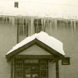
Central School
Snow and ice at Central School, Deer Park Avenue entrance, Kimberley BC.
| Internal ID: |
0139.0013 |
| Medium: | Photograph |
|---|
| Date: |
1930 |
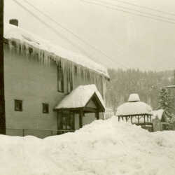
Central School
Snow and ice at Central School, Deer Park Avenue entrance, Kimberley, BC.
| Internal ID: |
0139.0014 |
| Medium: | Photograph |
|---|
| Date: |
1930 |
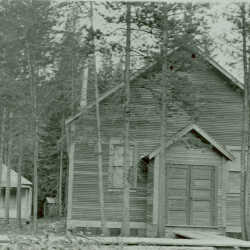
Kimberley First United Church
First United Church facing Deer Park with Manse beside facing Boundry Ave., ca. 1925. Present day church ( 1985 ) is in place of Manse.
| Internal ID: |
0146.0137 |
| Medium: | Photograph |
|---|
| Date: |
1925 |